Data Policy
GAW Data Policy
"For Scientific purposes, access to these data is unlimited and provided without charge.
By their use you accept that an offer of co-authorship will be made through personal contact with the data providers
or owners whenever substantial use is made of their data.
In all cases, an acknowledgement must be made to the data providers or owners and to the data centre when these data are used within a publication."
Version
2025-01-01-0111 (Last updated: 2024-12-24)File
This data set is submitted by UBAG.
In line with the GAW Data Policy, users should contact the contributors of all data of interest and propose co-authorship or acknowledgement.
Organization
| NO | 71 |
|---|---|
| Acronym | UBAG |
| Name | German Environment Agency |
| Address 1 | Umweltbundesamt, Wörlitzer Platz 1, 06844 Dessau-Roßlau |
| Address 2 | Umweltbundesamt (Federal Environment Agency) FG II4.5, Air Monitoring Network, Paul-Ehrlich-Str. 29, 63225 Langen |
| Address 3 | |
| Country/Territory | Germany |
| Website | https://www.umweltbundesamt.de/gaw |
Contact(s)
| Name | Frank Meinhardt |
|---|---|
| Prefix | |
| frank.meinhardt@uba.de | |
| Organization No | 71 |
| Organization acronym | UBAG |
| Organization name | German Environment Agency |
| Organization country/territory | Germany |
| Address 1 | Umweltbundesam Messstation Schauinsland |
| Address 2 | Schauinslandweg 2 |
| Address 3 | 79254 Oberried-Hofsgrund |
| Country/territory | Germany |
| Tel | +4934021036810 |
| Fax | |
| Last updated date | 2025-10-20 |
| Background observation | |
| UTC+01:00 | |
| ppm | |
|
9999-12-31 00:00:00 - 2017-12-31 23:59:59: WMO CO2 X2007 |
|
|
9999-12-31 00:00:00 - 2017-12-31 23:59:59: Hewlett Packard Modified HP 6890 GC 020394(Gas chromatography (FID)) |
|
|
9999-12-31 00:00:00 - 2005-09-30 23:59:59: 6 (m) 2005-10-01 00:00:00 - 2017-12-31 23:59:59: 12 (m) |
|
| 5 minutes | |
|
Calibration gas: CO2 in natural air. Calibrations are carried out every 15 minutes using secondary standard tanks, which have been calibrated to primary standards of NOAA/CMDL. Current Scale: NOAA scale |
|
| All values are quality controlled | |
|
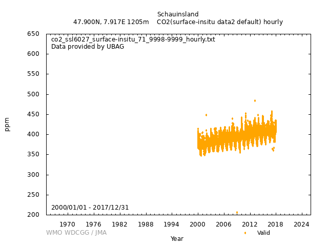
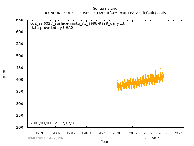
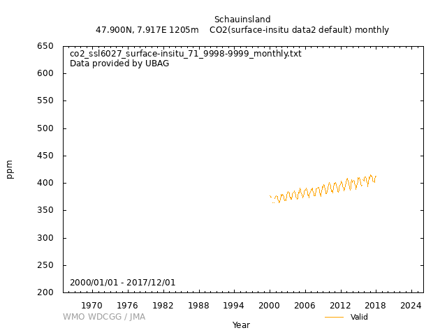
[Hourly] The data acquisition system provides two ambient air values, and one calibration value every 15 minutes. Invalid data caused by local impact or malfunctions are detected by a second CO2 instrument (IR), meteorological data and with information from the station logbook and then are rejected. 30 min mean values are generated by calculating the arithmetic mean of the remaining data with more than 2/3 of all data. For reporting to WDCGG hourly mean values are calculated from these half hourly data. [Daily] Take the arithmetic mean of selected half hourly data with the number of data more than 31. [Monthly] Take the arithmetic mean of selected half hourly data with the number of data more than 960. |
|
|
Flags put on hourly data are as follows. ...- 2005: 1 = valid value, 6 = calibration, 9 = error code 2006 -...: 0 = valid value, 3 = invalid data, 6 = calibration |
|
| Terminated | |
|
GC equipped with a packed column and a flame ionisation detector (FID). Modified GC system with ChemStation Software for quasi-continuously, automatically application. |
|
|
Wind direction: 1 Wind speed: 1 Relative humidity: 1 Precipitation amount: 0 Air pressure: 1 Air temperature: 1 Dew point temperature: 0 Sea water temperature: 0 Sea surface water temperature: 0 Sea water salinity: 0 Sea surface water salinity: 0 |
|
|
Meteorological data may remain as first provided, even when greenhouse gas data are updated. The height of the meteorological sensors has changed in 2006 from 10m above station level (1205m) to 35m above station level. This is visible in the increase of the windspeed data. |
No DOI available
Related information
GAW Data Policy
"For Scientific purposes, access to these data is unlimited and provided without charge.
By their use you accept that an offer of co-authorship will be made through personal contact with the data providers
or owners whenever substantial use is made of their data.
In all cases, an acknowledgement must be made to the data providers or owners and to the data centre when these data are used within a publication."
Citation format
This format is an example of the WDCGG standard citation.
Please follow the citation format which the data providers or owners indicate.
Please follow the citation format which the data providers or owners indicate.
Frank Meinhardt (UBAG),
Atmospheric CO2
at Schauinsland by German Environment Agency,
dataset published as CO2_SSL6027_surface-insitu_UBAG_data2 at WDCGG,
ver. 2025-01-01-0111 (Reference date*: YYYY/MM/DD)
* As the reference date, please indicate the date you downloaded the files.
* As the reference date, please indicate the date you downloaded the files.
Reference(s)
| 1 | http://www.umweltbundesamt.de/luft/luftmessnetze/ubamessnetz.htm |
|---|---|
| 2 | "Qualitatssicherungs-Handbuch des UBA-Messnetzes", UBA Texte 28/04, (Handbook for quality assurance for the measurement network for the Federal Environmental Agency, Germany), Dr.Klaus Nienerowski, Umweltbundesamt, Berlin, Juni 2004 |


