Data Policy
GAW Data Policy
"For Scientific purposes, access to these data is unlimited and provided without charge.
By their use you accept that an offer of co-authorship will be made through personal contact with the data providers
or owners whenever substantial use is made of their data.
In all cases, an acknowledgement must be made to the data providers or owners and to the data centre when these data are used within a publication."
Version
2025-06-24-1607 (Last updated: 2025-06-27)File
This data set is submitted by BMKG.
In line with the GAW Data Policy, users should contact the contributors of all data of interest and propose co-authorship or acknowledgement.
Organization
| NO | 10 |
|---|---|
| Acronym | BMKG |
| Name | Agency for Meteorology, Climatology and Geophysics |
| Address 1 | |
| Address 2 | |
| Address 3 | Jl. Angkasa I No.2 Kemayoran Jakarta Pusat, DKI Jakarta 10720 P.O. Box 3540 Jkt |
| Country/Territory | Indonesia |
| Website | http://bmkg.go.id |
Contact(s)
| Name | Reza Mahdi |
|---|---|
| Prefix | |
| reza_elka@yahoo.com | |
| Organization No | 10 |
| Organization acronym | BMKG |
| Organization name | Agency for Meteorology, Climatology and Geophysics |
| Organization country/territory | Indonesia |
| Address 1 | Stasiun Pemantau Atmosfer Global Bukit Kototabang |
| Address 2 | Jl Raya Bukittinggi-Medan Km 17 Palupuh |
| Address 3 | 26100, Bukittinggi |
| Country/territory | Indonesia |
| Tel | |
| Fax | |
| Last updated date | 2025-10-02 |
| Name | Okaem, Tanti Tritama |
|---|---|
| Prefix | Ms. |
| tantitritama@gmail.com | |
| Organization No | 10 |
| Organization acronym | BMKG |
| Organization name | Agency for Meteorology, Climatology and Geophysics |
| Organization country/territory | Indonesia |
| Address 1 | |
| Address 2 | |
| Address 3 | Jl. Raya Bukittinggi-Medan Km. 17 Palupuh, District Agam, West Sumatera, Indonesia PO BOX 11 Bukittinggi 26100 |
| Country/territory | Indonesia |
| Tel | +62 752 7446089 |
| Fax | +62 752 7446449 |
| Last updated date | 2025-10-02 |
| Name | Martin Steinbacher |
|---|---|
| Prefix | Dr. |
| martin.steinbacher@empa.ch | |
| Organization No | 23 |
| Organization acronym | Empa |
| Organization name | Swiss Federal Laboratories for Materials Science and Technology |
| Organization country/territory | Switzerland |
| Address 1 | Ueberlandstrasse 129 |
| Address 2 | CH-8600 Duebendorf |
| Address 3 | Switzerland |
| Country/territory | Switzerland |
| Tel | +41 58 765 4048 |
| Fax | |
| Last updated date | 2025-10-02 |
| Name | Nahas, Alberth Christian |
|---|---|
| Prefix | Mr. |
| alberth.christian@bmkg.go.id | |
| Organization No | 10 |
| Organization acronym | BMKG |
| Organization name | Agency for Meteorology, Climatology and Geophysics |
| Organization country/territory | Indonesia |
| Address 1 | |
| Address 2 | |
| Address 3 | Jl. Raya Bukittinggi-Medan Km. 17 Palupuh, District Agam, West Sumatera, Indonesia PO BOX 11 Bukittinggi 26100 |
| Country/territory | Indonesia |
| Tel | +62 752 7446089 |
| Fax | +62 752 7446449 |
| Last updated date | 2025-10-02 |
| Name | Arifin, Ikhsan Buyung |
|---|---|
| Prefix | |
| ikhsanarifin07@gmail.com | |
| Organization No | 10 |
| Organization acronym | BMKG |
| Organization name | Agency for Meteorology, Climatology and Geophysics |
| Organization country/territory | Indonesia |
| Address 1 | Stasiun Pemantau Atmosfer Global Bukit Kototabang |
| Address 2 | Jl Raya Bukittinggi-Medan Km 17 Palupuh |
| Address 3 | 26100, Bukittinggi |
| Country/territory | Indonesia |
| Tel | +62 752 7446089 |
| Fax | +62 752 7446449 |
| Last updated date | 2025-10-02 |
|
|||||||
| Background observation | |||||||
| UTC+07:00 | |||||||
| ppm | |||||||
|
9999-12-31 00:00:00 - 9999-12-31 23:59:59: WMO CO2 X2007 |
|||||||
|
2009-01-01 00:00:00 - 2018-12-31 23:59:59: G1301 CO2/CH4/H2O analyzer from Picarro, Inc.(CRDS) 2019-01-01 00:00:00 - 9999-12-31 23:59:59: G2401 CO2/CH4/CO/H2O analyzer from Picarro, Inc.(CRDS) |
|||||||
|
9999-12-31 00:00:00 - 9999-12-31 23:59:59: 32 (m) |
|||||||
| 2 seconds | |||||||
|
Calibrations are performed every 47 to 61 hours with three calibration gases. From October 2010 until November 2011 three calibration gases prepared by the Central Calibration Laboratory (NOAA ESRL) were used for regular calibrations. Since November 2011, calibration gases prepared and compared with NOAA standard gases by the World Calibration Centre for Surface Ozone, Carbon Monoxide, Methane and Carbon Dioxide (WCC-Empa) are used. NOAA cylinders are still available on-site for recalibration of the WCC-Empa cylinders. Calibrations are performed every 10 days with three calibration gases and checking 2 gases (working and target gas) every 2 days. From Feb 2019 until now three calibration gases and 2 gases (working gas dan target gas) prepared by the Central Calibration Laboratory (NOAA ESRL) were used for regular calibrations. |
|||||||
| Data are usually processed in regular intervals on a monthly basis. Data are humidity corrected accounting for the bias due to remaining water, data are split in different subsets (calibrations, ambient air measured at three different levels above ground), transition data after switching from one regime to another are flagged, and 1-min averages are calculated. All calibration results are pooled and a monthly mean calibration is applied to all data of this particular month. | |||||||
|
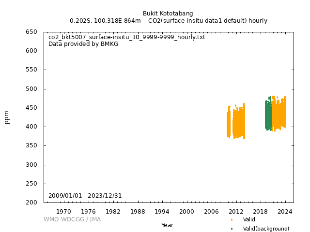
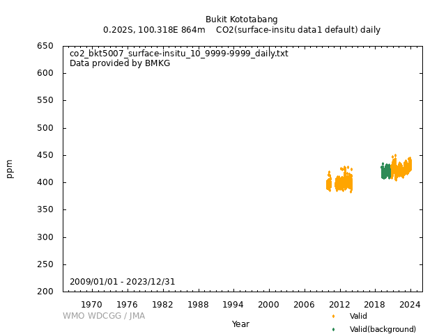
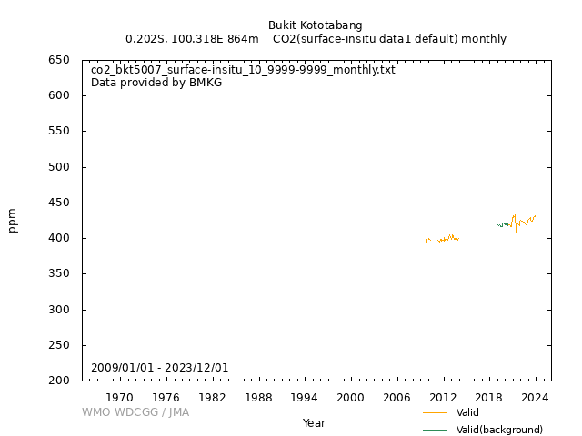
[Hourly] Hourly aggregates are calculated based on 1-min averages. ‘ND’ in the hourly data files refer to the number of available 1-min averages per hour. [Daily] The average data from 2009 to 2012 were calculated by WDCGG. [Monthly] The average data from 2009 to 2012 were calculated by WDCGG. |
|||||||
| Operational/Reporting | |||||||
|
Sampling from three different heights above ground (10m, 20m, 32m) is possible. From October 2009 until November 2011, all three sampling heights (10m, 20m, 32m above ground) were measured consecutively for 20min each. Since November 2011, more focus is given to the 32m level by running a 2-hour sequence with 80min sampling time from the 32m level followed by 20min from the 10m and 20m level, respectively. Description of Instruments : CO2 and CH4 observations are performed with a commercially available instrument (Picarro Inc. G1301) based on the Wavelength-Scanned Cavity Ringdown Spectroscopy technique coupled to a custom-built air sampling/calibration/drying unit. The sample air is dried prior to analysis by means of a Nafion dryer. Dry air mole fractions are determined by application of an empirical humidity correction to the dried gas data accounting for dilution and pressure broadening effects caused by the remaining water. Scientific Aim : Studying the long-term evolution of greenhouse gas mole fractions in the tropics region. Sampling Environment : The station is located in the middle of tropical rain forest. Thus, CO2 concentrations are partly driven by CO2 uptake and evaporation by the ample vegetation in the surroundings. The inlet 32m above ground is approximately 12 m above the canopy of the surrounding trees. Rice paddies are cultivated in the distant vicinity. The site is occasionally influenced by biomass burning in East Sumatra. |
|||||||
|
Wind direction: Wind speed: Relative humidity: Precipitation amount: Air pressure: Air temperature: Dew point temperature: Sea water temperature: Sea surface water temperature: Sea water salinity: Sea surface water salinity: |
|||||||
|
Meteorological data may remain as first provided, even when greenhouse gas data are updated. |
No DOI available
Related information
GAW Data Policy
"For Scientific purposes, access to these data is unlimited and provided without charge.
By their use you accept that an offer of co-authorship will be made through personal contact with the data providers
or owners whenever substantial use is made of their data.
In all cases, an acknowledgement must be made to the data providers or owners and to the data centre when these data are used within a publication."
Citation format
This format is an example of the WDCGG standard citation.
Please follow the citation format which the data providers or owners indicate.
Please follow the citation format which the data providers or owners indicate.
Reza Mahdi (BMKG),
Okaem, Tanti Tritama (BMKG),
Martin Steinbacher (Empa),
Nahas, Alberth Christian (BMKG),
Arifin, Ikhsan Buyung (BMKG),
Atmospheric CO2
at Bukit Kototabang by Agency for Meteorology, Climatology and Geophysics,
dataset published as CO2_BKT5007_surface-insitu_BMKG_data1 at WDCGG,
ver. 2025-06-24-1607 (Reference date*: YYYY/MM/DD)
* As the reference date, please indicate the date you downloaded the files.
* As the reference date, please indicate the date you downloaded the files.
Reference(s)
| 1 | Additional data from sampling heights 10m and 20m above ground are also available on demand; please contact the principal investigator. |
|---|---|
| 2 | http://gaw.empa.ch/gawsis |
| 3 |
Nahas, A. C., Greenhouse Gases Monitoring Activities at Global GAW Station Bukit Kototabang, Indonesia, Asian GAW Greenhouse Gases Newsletter, 3, 12-14, 2012. http://www.climate.go.kr/home/Eng/files/2012_Asian%20GAW%20Greenhouse%20Gases%20Newsletter%20Vol3.pdf (The diurnal cycle shown in Figure 4 must be based on the Picarro data, even if it isn’t explicitly stated. The trends are based on the NOAA flasks) |


