Captions of Figures
PLATE
- Plate1
- Variation of zonally averaged monthly mean CO2 concentrations (top), deseasonalized concentrations (middle) and growth rates (bottom). Zonally averaged concentrations are calculated for each 20-degree zone. Deseasonalized concentrations and growth rates are derived as described in 2.1. Long-term increase and seasonal variations can be seen clearly. Growth rates are high in 1983, 1987/1988, 1994/1995 and 1998, but exceptionally low with negative values in 1992.
- Plate2
- Monthly mean CO2 concentrations for all sites reported to the WDCGG illustrated in colors that change with the concentration. The sites are set from north to south. Though some stations reported data at two or three different altitudes, only data at the lowest altitudes are illustrated. The monthly value at the site which has submitted only original (hourly) data before selection is calculated by the WDCGG as an arithmetric mean, and may become high for reflecting the concentraion influenced in plant breathing at nighttime in the lower boundary layer.
- Plate3 (top, middle, bottom)
- The same as Plate1, except that this is for CH4. Long-term increase and seasonal variations can be seen. Growth rates decreased distinctly from the 1980s to 1990s. Growth rates declined to negative values in 1992 in northern high latitudes and to around zero in 1996, but increased largely in 1998 in both hemispheres.
- Plate4
- The same as Plate2, except that this is for CH4.
CO2
- Fig.3.1
- Monthly mean concentrations (dots and thin line) and deseasonalized long-term trends (thick line) from 1983 to 2000 for the globe and both hemispheres.
- Fig.3.2
- Growth rates from 1983 to 2000 for the globe and both hemispheres.
- Fig.3.3
- Monthly mean CO2 concentrations (dots and thin line) and deseasonlized long-term trends (thick line) from 1983 to 2000 for each 30-degree latitudinal zone.
- Fig.3.4
- Deseasonalized long-term trends (top) and growth rates (bottom) for each 30-degree latitudinal zone.
- Fig.3.5
- Time series of CO2 growth rates in the tropics(30üŗN-30üŗS) and their comparison with the Southern Oscillation Index inversed sign (top), SST anomaly in Region B (4üŗN-4üŗS, 150üŗW-90üŗW) (middle) and temperature anomaly of 1000 hPa on land in the tropics calculated from NCEP reanalysis data (bottom). The solid lines show the growth rates, and the dots show each element (5-month running mean).
- Fig.3.6
- Averaged seasonal cycle for each 30-degree latitudinal zone.
- Fig.3.7
- Latitudinal distributions of monthly mean CO2 concentrations in January, April, July and October in 1999.
- Fig.3.8
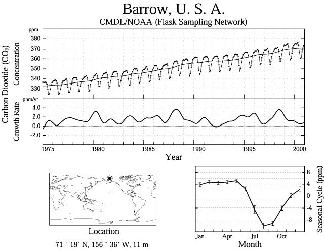
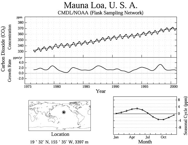
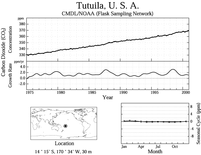
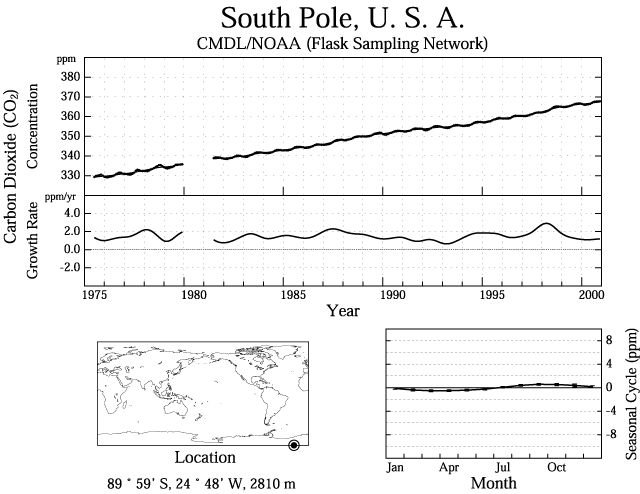
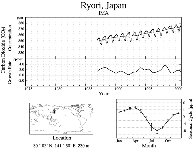
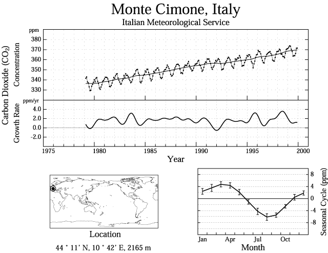
- Upper Panel: Monthly mean CO2 concentrations (dots and thin line) and deseasonalized long-term trends (thick line); Lower Panel: Growth rates; Bottom Right Figure: Averaged seasonal cycle; the error bars represent ü}1 standard deviation which shows interannual variability.
CH4
- Fig.4.1
- Monthly mean concentrations (dots and thin line) and deseasonalized long-term trends (thick line) from 1984 to 2000 for the globe and both hemispheres.
- Fig.4.2
- Growth rates from 1984 to 2000 for the globe and both hemispheres.
- Fig.4.3
- Monthly mean CH4 concentrations (dots and thin line) and deseasonlized long-term trends (thick line) from 1984 to 2000 for each 30-degree latitudinal zone.
- Fig.4.4
- Deseasonalized long-term trends (top) and growth rates (bottom) for each 30-degree latitudinal zone.
- Fig.4.5
- Averaged seasonal cycle for each 30-degree latitudinal zone.
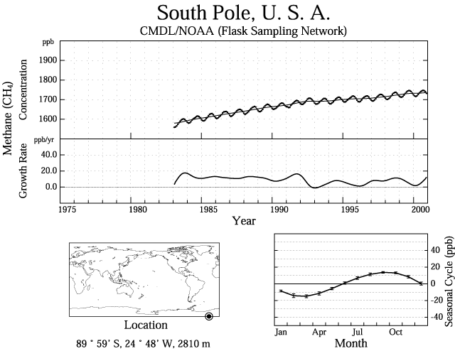
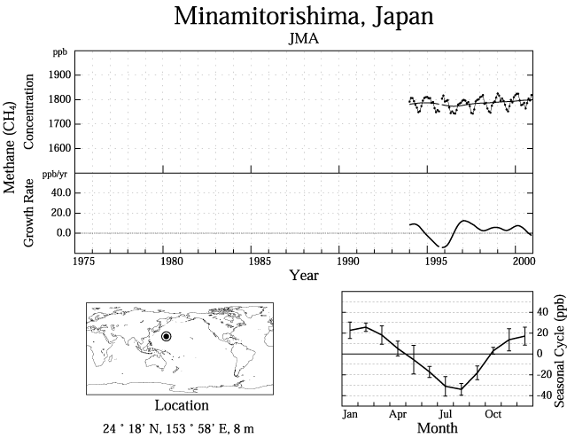
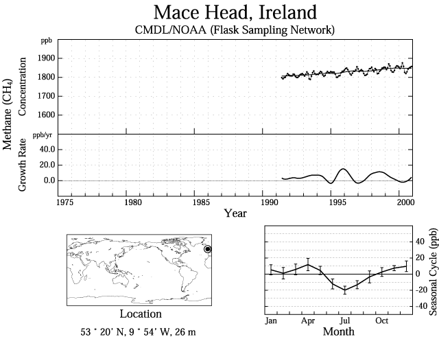
- Fig.4.6
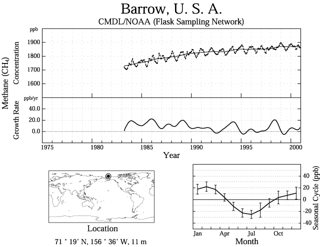
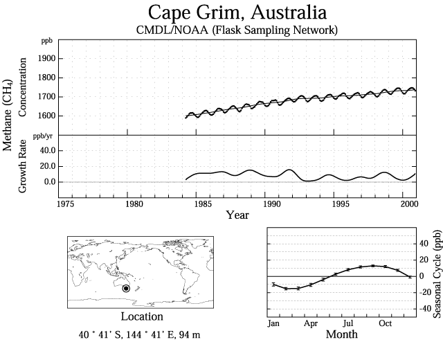
- Upper Panel: Monthly mean CH4 concentrations (dots and thin line) and deseasonalized long-term trends (thick line); Lower Panel: Growth rates; Bottom Right Figure: Averaged seasonal cycle; the error bars represent ü}1 standard deviation, which shows interannual variability.
N2O
- Fig.5.1
- Time series of monthly mean N2O concentrations. Observation data at the sites listed below is shown.
Halocarbons
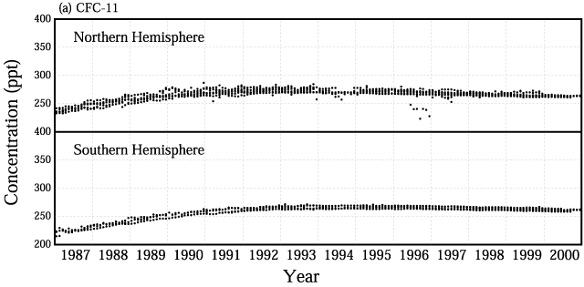
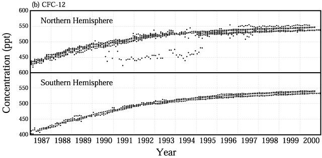
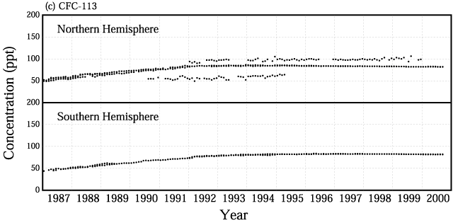
- Fig.6.1
- Time series of monthly mean concentrations of (a)CFC-11, (b)CFC-12, (c)CFC-113. Observation data at the sites listed in Table 6 A are shown.
- Fig.6.2
- Time series of monthly mean concentrations of HCFC-141b (upper panel) and HCFC-142b (lower panel). Observation data at the sites listed in Table 6 A are shown.
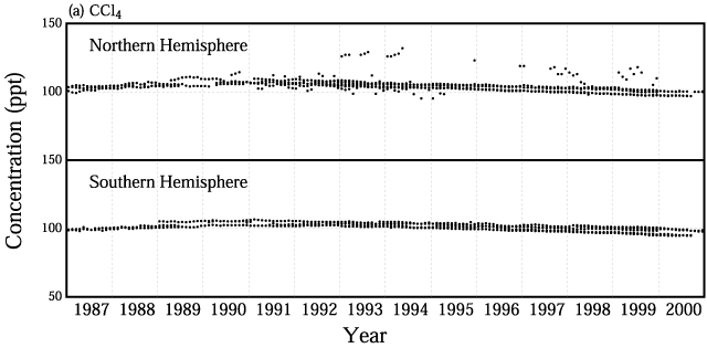
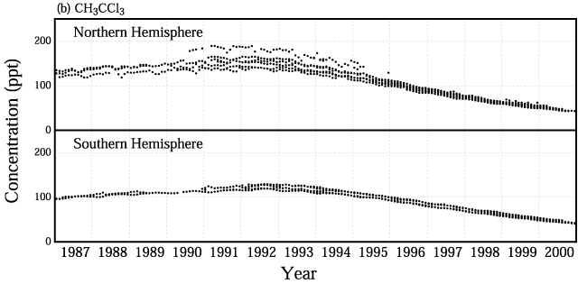
- Fig.6.3
- Time series of monthly mean concentrations of (a)CCl4 and (b)CH3CCl3. Observation data at the sites listed in Table 6 A are shown.
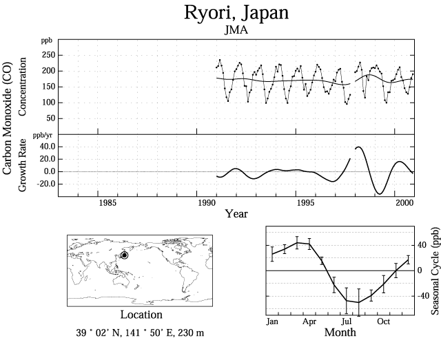
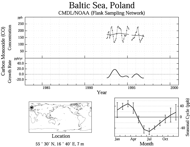
CO
- Fig.7.1
- Variation of zonally averaged monthly mean CO concentrations (upper) and deseasonalized concentrations (lower). Zonally averaged concentrations are calculated for each 20-degree zone. Deseasonalized concentrations are derived as described in 2.1. Seasonal variations can be seen clearly.
- Fig.7.2
- Monthly mean concentrations (dots and thin line) and deseasonalized long-term trends (thick line) from 1992/1993 to 1996 for the globe and both hemispheres.
- Fig.7.3
- Growth rates from 1992/1993 to 1996 for the globe and both hemispheres.
- Fig.7.4
- Monthly mean concentrations (dots and thin line) and deseasonlized long-term trends (thick line) from 1992/1993 to 1996 for each 30-degree latitudinal zone.
- Fig.7.5
- Deseasonalized long-term trends (top) and growth rates (bottom) for each 30-degree latitudinal zone.
- Fig.7.6
- Averaged seasonal cycle for each 30-degree latitudinal zone.
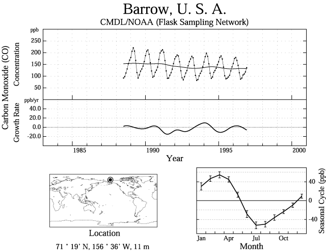
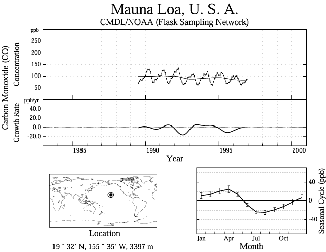
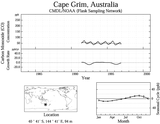
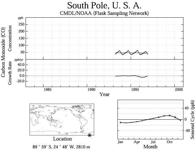
- Fig.7.7
- Upper Panel: Monthly mean CO concentrations (dots and thin line) and deseasonalized long-term trends (thick line); Lower Panel: Growth rates; Bottom Right Figure: Averaged seasonal cycle; the error bars represent ü}1 standard deviation, which shows interannual variability.
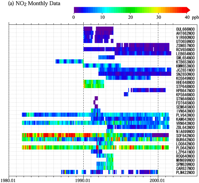
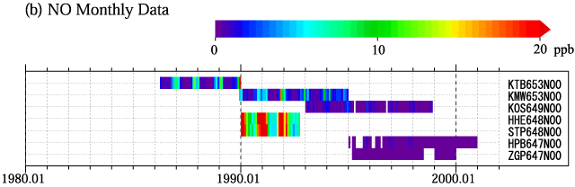
NOx
- Fig.8.1
- Monthly mean concentrations of (a)NO2 and (b)NO for all stations reported to the WDCGG. The stations are set from north to south.
SO2
- Fig.9.1
- Monthly mean concentrations of SO2 for all stations reported to the WDCGG. The stations are set from north to south.
|
Data Summary No.26 contents |